 Carter Basin was as exquisite at sunrise as last night at sunset. The morning clouds are light and puffy. A gentle wind pushes the CAP’N LEM this way and that on the anchor string. I had marked the channel well with a series of way points to ensure a safe exit no matter what the tide was doing. I deferred getting underway until 0900.
Out in the bay I could see one lone boat going somewhere on calm waters. A loon cruised the mouth of the basin looking for an early lunch. As I went from waypoint to waypoint the fathometer dropped 16feet-14-10-7-6.5-5-4-3.6, then rose ever so slowly 4-5-6-9-14-24 and I stopped watching it. I was over the bar. I added more waypoints to be saved for next year’s return.
My next obstacle is the Goose Bay Narrows. Eons of glaciers and runoff have filled Goose Bay with long rocky shoals and sand bars too shallow even for the CAP’N LEM so I’m confined to closely follow the marked channel through the Narrows. The chart shows too many one foot marks.
And as we so well know, how things start out is no indication of how they will end up. By the time I reached the first red buoy at the north end of the Narrows, the wind was 25kts right on the nose. Tacking in these confined spaces was not worth the effort. The over the ground speed dropped to ½ knot and the motor started to hobbyhorse out of the water. I gave up! The only shelter to be found was back the way we came. Once again, 14-9-6-5-4-3.6-4-5-6-7-10 across the bar and into Carter Bay. The loon had found his lunch and was gone. This time I anchor just inside so I can keep an eye on the bay.
No more had I anchored than the wind died to 0. In a half-hour the bay was calm, in an hour, glass. Up the anchor and go again, 5-4-3.5-4-5 and over the bar. What else is there to do? But glassy waters never stay glassy. First a ripple, then a gurgle, and time to get some sail up. The wind was not what I wanted and not what I needed but with a tight trim and the motor ticking over to help keep the edge sucking me forward I can do the Narrows. In this place, though, the wind is either building or dying and once again in the Narrows it’s building. Oh, I can see the goal. If I can just clear the channel I can fall of enough to make it to Rabbit Island then tack on in but the going is slow with the waves building along with the wind. It is a delicate balance but I can make a short tack or two. Anything but backtrack again. This is not this morning’s wind though it’s close. The CAP’N LEM can to it.
The AIS indicates traffic coming this way. The TANKER NANNY is inbound and needs the channel. We talk on VHF #10. I assure her should I still be in the channel when she enters I will go outside and stay outside the markers. I try very hard to not be a concern for any commercial traffic.
The wind is 20 knots with gust higher. I make plans, check charts and positions, even ready my anchor should the unthinkable happen and I lose power just as she’s coming by. I live by Murphy’s Law in all its variations. “Anything that can go wrong will go wrong and even if it can’t it still might,” and that’s the optimistic version.
I clear the south end just as she enters the north but still I hold my close heading into the wind by sacrificing speed. CAP’N LEM barely makes 1 knot over the ground not wanting to even suggest we might try crossing in front.
Of course she passes without incident and I’m able to turn off the wind and start making up the speed the channel cost me. With my reefed main and very short jib, the TANKER NANNY walks away toward Goose Bay with me following behind.
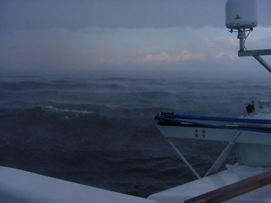
Then a day filled with changes gets even fuller. To the west is a squall line, a big squall line getting bigger by the minute. First the sun is blocked, then the sky, then the land under the sky. The wind I’ve battled to clear the Narrows changes ever so slight, the waves act confused like a child lost in a crowd. The air is warm and electric. And it’s coming for me.
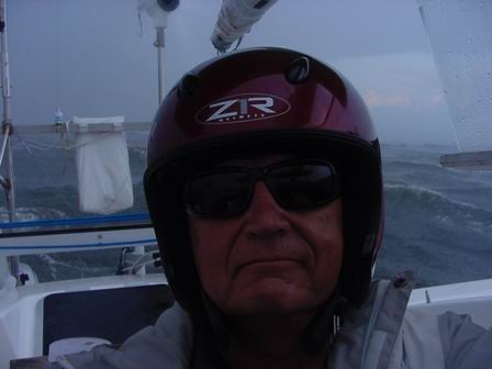
No running this time, and no hiding. It’s just too far. I get ready. Off in the distance the NANNY is engulfed in rain and I lose my visual reference point for Goose Bay. I put on rain gear, my helmet and my gloves. I reef even farther down. I double check my safety line around my waste. I double check my fuel; I’ll be needing that extra push to hold my headings. I take up my station under the hard dodger and standing on the wooden steps and watch. I even put on my sunglasses should a lighten strike close. Maybe it would help keep from blinding me. I do everything I can think of because this baby’s got everything. Lighten, rain, zero vis, and lots and lots of wind. What have I go? I’ve got the CAP’N LEM and some sea room, not a lot, but some.
The water turns black and oily looking. The old wind dies and the new wind is born screaming so hard it flattens the previous southwest waves to nothing then commences to rearrange the sea to its liking. The rain pelts the boat and off we go! First one way then another. By using the engine, I keep from turning down wind and merely run back and forth. The amas bury then rise casing of one wave after the other. The bow does her part breaking water and helps keep the speed down. The speed I would reach running down wind would soon eat up my sea room and I hate the thought of threading the Narrows in this. For now, things are ok. Lighten strikes somewhere and thunder follows soon. Still, things are ok. I leave the GPS and the radar on. I need them. I inspect everything. The akas are stiff and working like wings holding the body stable in the building waves. The mainsail is tight and pulling hard. The little ever faithful motor is giving steerage way. The dagger board is down and tight. The auto pilot, my beautiful epoxy smeared autopilot holds the rudder.
A squall line is just that, a line. It moves over me with all the indifference nature can show a fool, and I see a bright spot to the west. Now it’s that bright spot that is getting bigger. Then, the speck that is the TANKER NANNY reappears. The wind doesn’t stop; it just leaves to travel with its companion the rain. It’s still another two hours before the water calms down, though. Once again, I make progress.
At 1030 local time, the charming little anchorage in Carter Basin becomes my “next to last” anchorage as I drop the hook one more time inside of Torrington Basin at Lat. 53⁰ 21′ 17.7″N ~ Long. 060⁰ 24′ 29.2″W in 16 feet of water having traveled 3366 nautical miles in 4 months from Two Harbors Minnesota.

